


TTR® is a run held in the natural environment following ancient paths and routes in the midst of history and nature.
We offer 5 routes, for a day of sport in the heart of the most important parts of the “Food Valley” , home to Fragno Truffles, Parma ham, Parmesan cheese and wine from our hills.
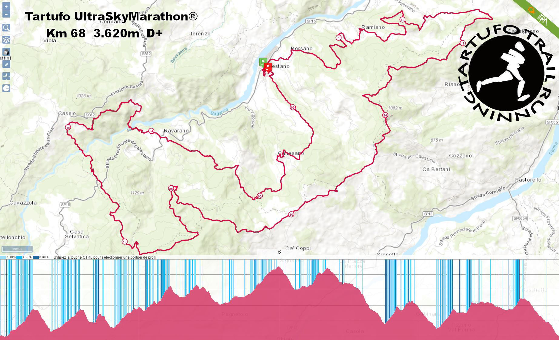
Km. 8,4 (D+ 450 m. ), Km. 17,6 (D+ 1.000 m.), Km. 28,3 (D+ 1.5600m.), Km. 43,5 (D+ 2.250 m.) and Km. 67,8 (D+ 3.620 m.)
These difficult routes include sections along mountain paths with areas considered excursionist in nature (Italian Alpine Club definition type E ) and the conditions can be very demanding (wind, cold, fog, rain and snow all possible) and the temperature ranges from - 5°C to + 20°C
Therefore the following are essential: a good physical preparation, appropriate diet, a high level of autonomy, for example knowledge of mountain running and maximum vigilance
Runners are strongly advised to participate in less demanding trail races before attempting this race.
The routes of the TTR® are certified with UTMB and ITRA and are worth the following points:
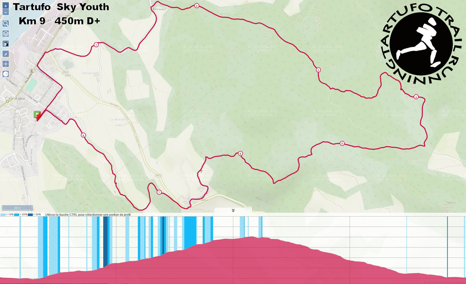
km. 9 D+ 450 m. Tartufo Sky Youth - COPPA ITALIA Giovani YOUTH A e B
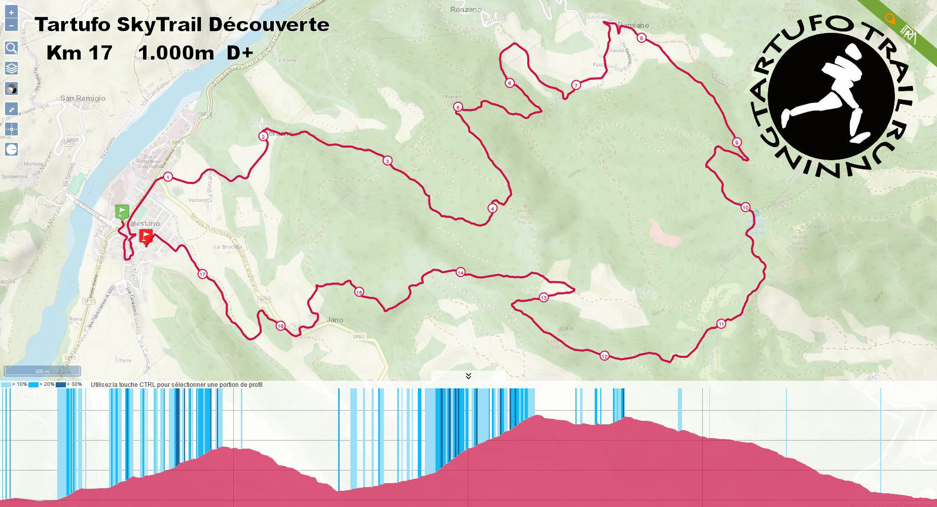
km. 17 D+ 1.000 m. Tartufo SkyTrail Découverte ( Qualifying Race 2024 "U.T.M.B."- 20K M)
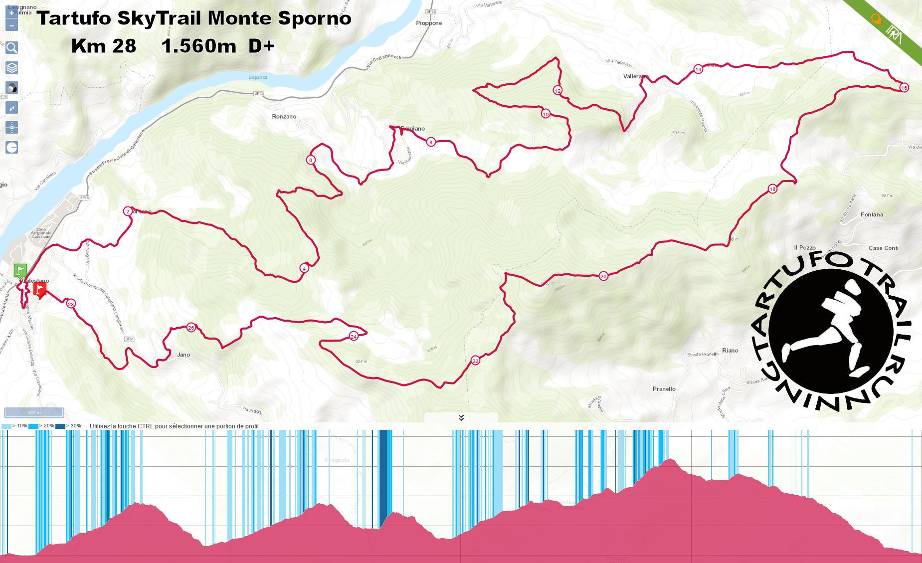
Km. 28 D+ 1.560 m. Tartufo SkyTrail Monte Sporno ( 1 Points ITRA - Qualifying Race 2024 "U.T.M.B."- 20K M)
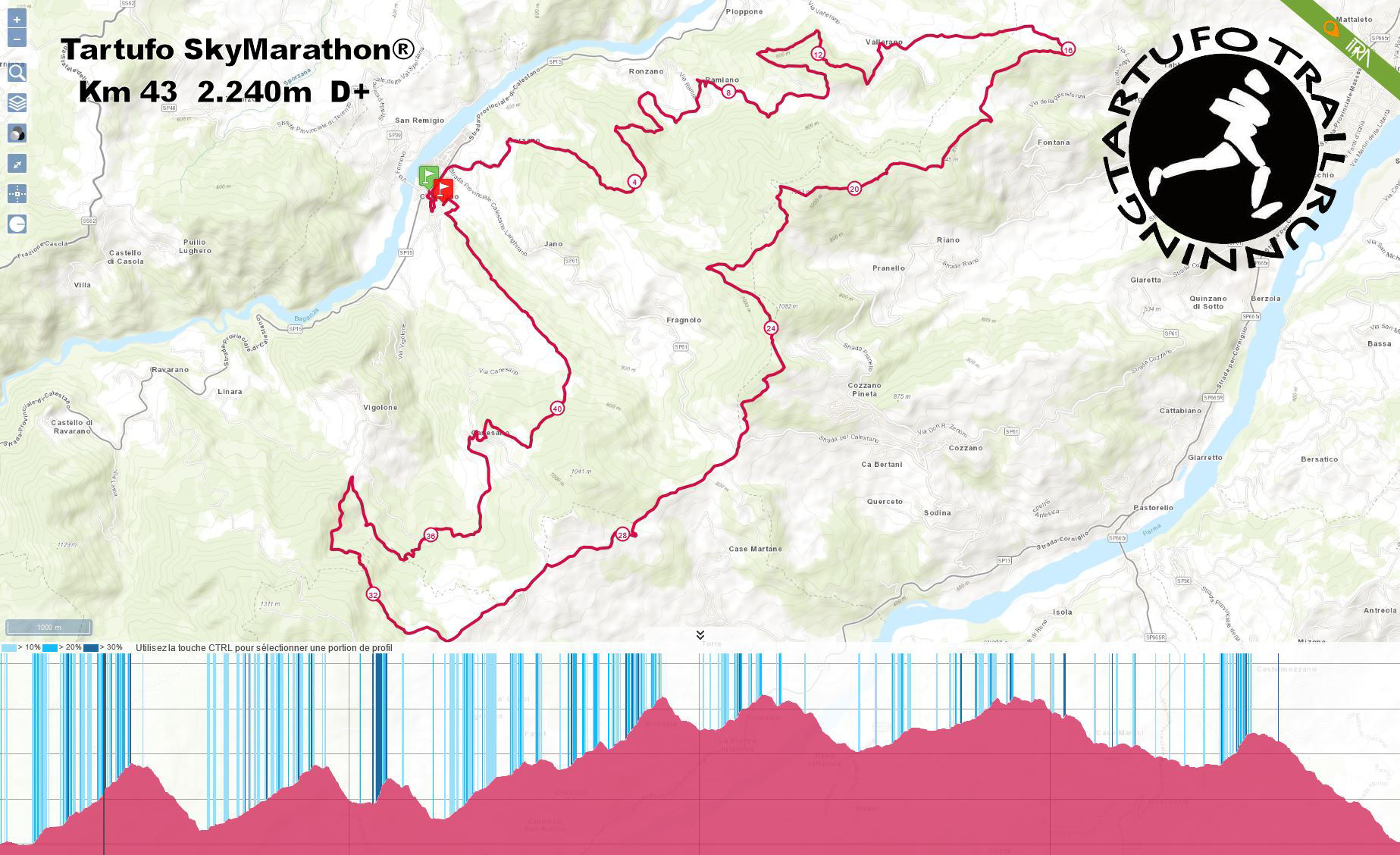
Km. 43 D+ 2.250 m. Tartufo SkyMarathon® ( 2 Points ITRA - Qualifying Race 2024 "U.T.M.B."- 50K M) - CRAZY Skyrunning Italy Cup
Km. 68 D+ 3.620 m. Tartufo Ultra SkyMarathon® (3 Points ITRA - Qualifying Race 2024 "U.T.M.B."- 100K M)
TECHNICAL INFORMATION:
- the 9 km route is divided into: (1km ) 11% asphalt, (6 km) 71% on earth or gravel, (2 km) 18% single track
- the 17 km route is divided into: (2km ) 11% asphalt, (12 km) 71% on earth or gravel, (3 km) 18% single track
- the 28.4 km route is divided into: (4km ) 14% asphalt, (19 km) 68% on earth or gravel, (5 km) 18% single track
- the 43.7 km route is divided into: (3,7km ) 8% asphalt, (33 km) 75% on earth or gravel, (7 km) 17% single track
- the 68 km route is divided into: (6 km ) 8% asphalt, (51 km) 75% on earth or gravel, (11 km) 17% single track
All the routes are permanently indicated by triangular signs (12 cm wide) and reflective yellow directional arrows. There will be 1 Control Point on the 17-km route; 3 CPs on the 28.4-km route ; 5 CPs on the 43.7-km and 6 CPs on the 68 -km route
All the CPs will be manned by Tartufo Trail Staff. To certify completion of each stage of their route, participants must stop at each CP to verify their progress.
Any participant who withdraws from the race is required to advise the Staff at the nearest CP as soon as possible and return their race bib.
In the event that an official search party has to search for a participant who has withdrawn without informing Tartufo Trail Staff, any associated costs will be charged to the participant.
AID STATIONS:
There will be:
1 – Aid station with solid food and liquids on the 17-km route (at 11,9-km)
2 – Aid stations ( 1 water point and 1 solid food and liquids ) on the 28-km route (at 13,5-km and at 22,8-km)
3 – Aid stations ( 1 water point and 2 solid food and liquids ) on the 43-km route (at 13,5-km, at 22,8-km and at 34-km)
5 – Aid stations ( 1 water point and 4 solid food and liquids ) on the 68-km route (at 13,5-km, at 22,8-km, at 34-km, at 51,6-km and at 58,3-km)
on the route there are various marked fountains and natural springs (like at 45-km)
Plastic cups will not be available at the water points, therefore all runners must provide their own glass or container for drinking
MAXIMUM TIME LIMITS AND CUT OFF TIMES; WITHDRAWING FROM THE RACE:
For the 9 -km route there are no time limit/cut off point
For the 17 -km and 28 -km route there is one time limit/cut off point at PC 3 - 23 -km by 1:00 p.m. - 5 hours into the race
For the 43-km runners and 68 -km runners there is one time limit point at 23-km, 4h00 after the start
(last call for runners on 68 -km routes is at 11:00 a.m. and for runenrs on 43 -km is at 12:00 a.m. – average speed of 5,8 kph, 10 minutes and 26 seconds per km)
Anyone arriving at the CP after this hour will be required to join the 28-km race, where it will be classified without penalty
Anyone arriving at the CP before this hour can choose to finish the 43 -km or 68 -km race for which they are registered, or the 28-km race.
For the 68-km runners there are still two time limit/cut off points:
- Before the road crossing 43 km path at 31 -km - Cut of Time by 0.20 p.m. - 5 hours 20 minutes into the race
Anyone arriving after this hour will be required to join the 43 -km race, where it will be classified without penalty
and
- Leaving the gravelled carriageway at 62- km - Canesano - Cut of Time by 6.20 p.m. - 11 hours 20 minutes into the race
Athletes who do not reach these points by the established time limits will not be allowed to continue the race.
Race officials reserve the right to disqualify athletes who disrespect the rules. Runners who pass this point after this time must leave the race, and return their bib to a race organiser. A free shuttle service will take such runners back to the Finish Point at Calestano, in front of the Baita degli Alpini.
Any participant who withdraws from the race is required to advise the Staff at the nearest CP as soon as possible and return their race bib.
In the event that an official search party has to search for a participant who has withdrawn without informing TTR Staff, any associated costs will be charged to the participant
The maximum time allowed to reach the finish line for the 43-km is 11 hours (average speed of 3,9 kph, 15 minutes, 20 seconds per km)
The maximum time allowed to reach the finish line for the 68-km is 12,30 hours (average speed of 5,7 kph 10 minutes, 35 seconds per km)
Download Road Book
Route on GPS
TRACE DU TRAIL |
GPX |
| Route - 9 Km | |
| Route - 17 Km | |
| Route - 28 Km | |
| Route - 43 Km | |
| Route - 68 Km |
Tutti i percorsi sono segnalati in modo permanente con segnavia triangolari (lati cm. 12) , frecce direzionali giallo riflettente evidenziati da due bolli gialli fosforescenti sopra e sotto, da coppie di bolli fosforescenti e frecce gialli fosforescenti con scritta TT (Tartufo Trail)
 |
 |
 |
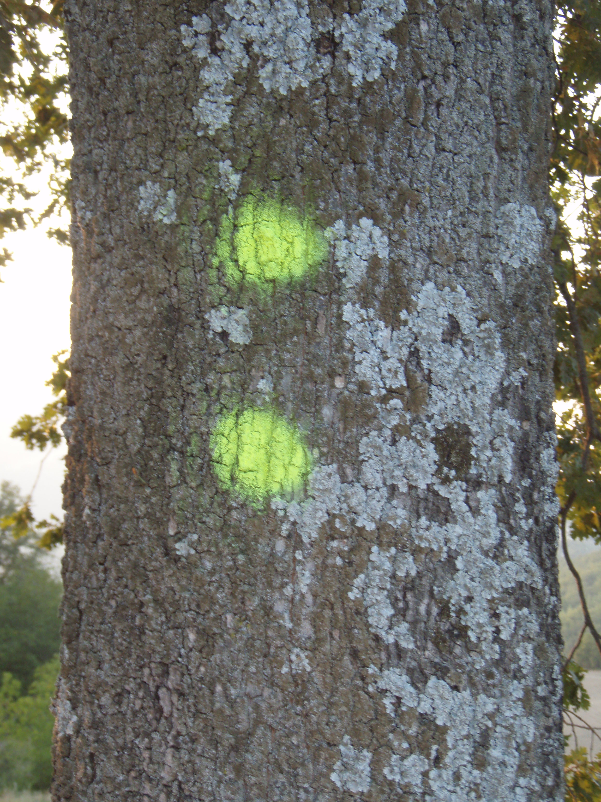 |
All the routes are permanently indicated by triangular signs (12 cm wide) and reflective yellow directional arrows
|
|
|
|